
Barking is an interchange railway station. It is served by London Underground, London Overground and National Rail Services (C2C). I am visiting it as it is the 9th station on the District Line (green coloured line on tube map) but it is also the Eastern Terminus for the Hammersmith and City Line (pink coloured line on tube map).
The station opened in 1854 and was rebuilt in 1889.
A new station with 8 platforms and
a 50ft wide bridge spanning nine lines was opened in 1908. The District Line extended Eastwards to Barking in 1932 shortly followed by the Hammersmith and City Line in 1936.
A new booking hall opened in 1961 with a new ticket office and shops installed in 1991.
The station building is a Grade II listed building because of its inclined concrete roof. I was surprised that there was no underground roundel visible on the platforms or on the outside of the building.

Instead it was visible on this signage by the roadside.
As I stepped outside the station it was obvious that this was the largest town I had visited on the District Line so far. There were numerous shops up and down the High Street. In 1965 Barking and Dagenham became one of the 32 London Boroughs, before that they were part of the county of Essex
Across from the Station is the Vicarage Field Shopping Mall. This was constructed in 1991 on the site of the former Vicarage Field football ground, home to Barking Football Club.
The shopping centre has been sold and is set to be redeveloped. The plan is to build over 800 new homes above the redeveloped shopping centre. They will be in tower blocks of varying heights with a new hotel, school and cinema included in the new development.

I was here on a Friday so it was market day. This made it difficult to photograph some of the buildings as they were obscured by market stalls.
This is the magistrates court. It is a Grade II listed building. Built in 1893 it still has the original railings, lamp holders and globe lamps.
Built in 1894, the Magistrates' Court was originally the Town Hall. It has been used as a court until recently and is now used for retail and accommodation.

From the market I walked through into a tree lined, square. It had residential blocks on one side and the Town Hall on the other side. This recent development consists of 500 flats, a library and a learning centre with a number of classes to improve adult literacy in the Barking area.
Impressive walkway by the side of the library.
Barking Council began to plan a new town hall in 1931. The building was delayed by WW2 and construction didn't start until 1954. The new town hall was finally opened in 1958. The tall clock tower ensures it is a local landmark.
To the right of the town hall is this wall. I walked around it, photographed it but I could find no plaque or information board. Someone suggested it had been found when they were building the supermarket which is the other side of the wall. But that explanation didn't ring true. I went into the town hall to see if they had any information which they didn't but someone suggested I visit the library.
The open plan, bright library felt very welcoming and was a hive of activity. The librarian I spoke to was well informed and a huge help. Not only did she enlighten me on the history of the wall but she located many helpful books on Barking and its history and places of interest.
The wall is a modern folly built in 2007 from architectural salvage including 9000 reclaimed bricks. It was created by the Muf, a collaborative practice of architects and artists. It was built by bricklaying apprentices from Barking and Dagenham College. I found the folly fascinating. A mixture of old sculptures, reliefs and bricks which will challenge the onlooker and the curious. Although I wonder how many people walk past and just assume it has always been there.
After looking around the Square I went in search of the Barking Abbey ruins and the Curfew Tower.
The old Barking Assembly Hall opened in 1961 replacing many old buildings. It is now called the Broadway Theatre.The Broadway was one of the original roads of the town and dates back to the Middle Ages. It was upgraded in the late 19th century when pavements were added. Many of the buildings to the east of the Broadway were demolished in 1937 to make way for a new town hall but with the outbreak of war in 1939 it wasn't built until much later.
In front of the Theatre is this statue. Job Drain fought during WW1 and was awarded the Victoria Cross, the highest military award for bravery, at the age of 18. He joined a group of soldiers who volunteered to save two artillery guns from the advancing enemy lines. He survived the war and returned to civilian life back in Barking and had a variety of jobs during his lifetime. He died in 1975 at the age of 79

Across the road from the theatre is the Curfew Tower, now the entrance to St Margaret's churchyard. The Tower was one of three gates leading to Barking Abbey and is the only one still remaining. Barking Abbey was founded in AD666 by a monk called Erkenwald for his sister Ethelburga. The first abbey was for both monks and nuns but was destroyed by Vikings in AD 871. It was restored about 100 years later as a single sex Benedictine nunnery. By 1066 it was large enough to accommodate the new King William the Conqueror and his followers. During that year many of the Saxon earls and lords may their way to the abbey to swear allegiance to their new king. In the centuries that followed Barking Abbey became the second richest abbey in the country.
The abbey was surrendered to the Crown in 1539 during the Dissolution of the Monasteries period. Demolition began the following year.
Excavation of the site began in 1910. Stone was used to rebuild the layout of the abbey.Further excavations in the 1960s found glass vessels, pottery and jewellery.
Within the Abbey grounds is the church of St Margaret's. It was here that Captain James Cook (1728-1779). one of Britain's great explorers married here in Dec 1762.
I walked around the church but no doors were open which was disappointing as I had just been reading about the history of the church in the library. Next to the church is the St Margaret's centre which was also closed but nothing ventured nothing gained so I pressed the buzzer on the centre's door. I was surprised when it was opened but so fortunate that it was opened by the organist from the church who was doing some work in the office and heard the doorbell. He invited me in and opened the church for me. He left me in the church and I had the privilege of looking around the church and absorbing its history without being disturbed. There is a café in St Margaret's Centre open 3 days a week but not on a Friday so I missed out but gained so much from having a medieval church all to myself..

St Margaret's dates from the middle of the 12th cent.Alterations have taken place over the centuries.The tower, nave, north and south aisles are 15th cent. In 1907 an oyster shell was found in a wall with the date 1501 scratched on it.
Some of the memorials made interesting reading.


The Fishermen's window has numerous nautical motifs. In the background is the tower of St Margaret's above the warehouses on the quay. The middle section depicts a short blue fishing vessel at sea with a hive of activity around the catch at the Town's quay. The window was designed by George Jack (1855-1931), a well known figure in the arts and craft movement.

The ornate baptismal font dates from the Spanish Armada(1588) and is said to have been given to St Margaret's by grateful sailors asa gift to God for ensuring their safe passage through the battle.
Sadly I forgot to ask the organist's name but we had a very pleasant chat before I left. He also directed me to the town quay which was just across the green.
Barking was a fishing village at one time so I was keen to see how close the river was to the town. In fact it was closer than I thought. It was just a couple of minutes walk from the church to the Barking Creek. The Town Quay was once the centre of a thriving seagoing fishing industry on which the success of the town was built. It declined in the 19th century when the shipping fleet moved to the east coast after the arrival of the railway made it easier to take the catch up to London. The area around the Quay became a centre of Barking's industry once the fishing business had declined. The early factories around the river used it as a main source of transport for bringing in raw materials and sending out finished goods. Barges could travel as far upriver as Ilford and then down to the Thames

The street lamps on the quay are decorated with fishing themes.


Now Barking is in the middle of one of the biggest regeneration schemes in London. The council has a target of building 50,000 homes and creating 20,000 new jobs in the next 20 years. This is all part of the Thames Gateway project which aims to boost the economy of the whole Thames estuary region through the development of marshland, farmland and brownfield ( land previously used for industrial or commercial purposes). It is the largest regeneration scheme in North West Europe.

However. there has been much criticism of these ambitious plans building homes so close to the Thames Estuary with the projected rise in sea levels. There is also worries about the strain on the environment and other scarce resources.
By the mid 19th century the Barking fishing fleet had increased to 150, mainly attributed to using ice as a way of keeping the fish fresher for longer. Buying ice from countries such as Norway was expensive but Samuel Hewitt, the owner of the largest fleet of boats in Barking had an idea how to make their own ice. Using sluice gates he flooded the marshes near Barking. The ice which formed in the winter was collected during a grand social occasion known as the Ice Harvest.
A large ice house was built near the town quay to store the ice for use during warmer weather. Farmers also began to flood their fields and sell the ice they produced. Today the ice house and surrounding warehouses are used as art and cultural centres as well as accommodation and restaurants. The area is known as the Ice House Quarter.
The old granary

I f
ollowed the Creek down to where it meets the River Roding which then flows into the River Thames.

After my walk by the river I returned to the centre of the town, stopping on the way to have some lunch in this cafe. There was nothing fancy about it but it offered simple food, a friendly welcome and value for money.
Back in the town I passed by this pub. The original Catholic services in Barking were held in the Red Lion until St Ethelberg's Church was built in 1869.
Now a Sikh Temple, this was the Friends Meeting House where Elizabeth Fry, a social reformer would preach. During her life Elizabeth Fry (1780-1845) campaigned for improved welfare for vulnerable people. opening shelters for the homeless, forming visiting societies for sick people and protested against slavery and capital punishment. She frequently preached at the Friends Meeting House. In 1845 she died and was buried in the burial ground across the road from the meeting house. More than a thousand people stood in silence during the burial.
Opposite the Sikh Temple is Quaker Gardens, a former Quaker burial ground established in 1672. Among those buried here was Elizabeth Fry. Her tombstone was moved to Wanstead Quaker Burial Ground where the Barking Meeting transferred in the late 18th century. In 1980 the burial ground became a small public garden and all remaining headstones and monuments were then removed.
Quakers disapproved of headstones in their burial grounds as they made a distinction between the rich, who could afford a memorial and the poor who could not. Only in 1850 did they officially allow headstones to be erected as long as there was no distinction in size between the stones.
The Spotted Dog, close to the high street, was built in about 1870 and then altered in 1884. The first licensee, who was deaf was tragically killed by a train whilst crossing the railway line.

At the other end of the high street in the middle of the roundabout is this steel sculpture called 'The Catch'.
Looking closer I could see that it was a pair of fishing nets, a nod to the town's heritage.
A couple of hundred metres from the roundabout is Barking Park a beautiful, landscaped park. It also has a miniature railway which I imagine is very popular with the children in the area.
It is well designed with many mature trees.
The town's war memorial has been built in the park.There has been a tradition of military bands giving concerts in the park for many years when, according to newspaper reports, thousands used to turn up to watch. Perhaps that connection to the military was one of the reasons for siting the memorial here.
One of the main features of the park is the lake which is more than half a mile long
By now it was late afternoon and the light was beginning to fade. I had enjoyed my day in Barking. I felt welcomed and found the people helpful and friendly. A reporter (Rowan Moore) from the Evening Standard newspaper summed it up well when he said 'Barking may be battered but it has good bones'.
Sharing with
Our World Tuesday
 Barking is an interchange railway station. It is served by London Underground, London Overground and National Rail Services (C2C). I am visiting it as it is the 9th station on the District Line (green coloured line on tube map) but it is also the Eastern Terminus for the Hammersmith and City Line (pink coloured line on tube map).


 I was here on a Friday so it was market day. This made it difficult to photograph some of the buildings as they were obscured by market stalls.
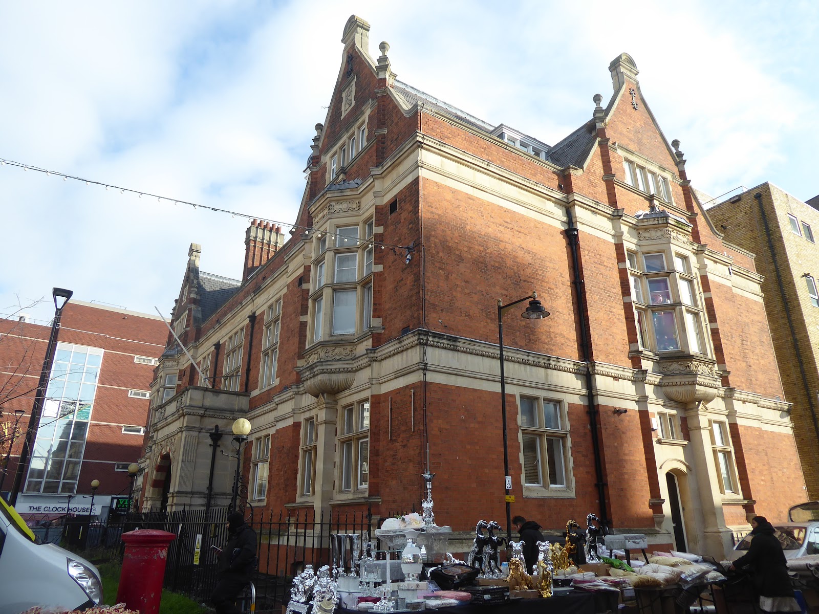


 St Margaret's dates from the middle of the 12th cent.Alterations have taken place over the centuries.The tower, nave, north and south aisles are 15th cent. In 1907 an oyster shell was found in a wall with the date 1501 scratched on it.


 Now Barking is in the middle of one of the biggest regeneration schemes in London. The council has a target of building 50,000 homes and creating 20,000 new jobs in the next 20 years. This is all part of the Thames Gateway project which aims to boost the economy of the whole Thames estuary region through the development of marshland, farmland and brownfield ( land previously used for industrial or commercial purposes). It is the largest regeneration scheme in North West Europe.


 At the other end of the high street in the middle of the roundabout is this steel sculpture called 'The Catch'.


