Although I left the hotel at 8am I didn't find the correct path until an hour later. There is no large river to follow now and the sign I was looking for was on a farm with 2 very unfriendly looking dogs. I walked round in circles before working out which way to go.
Cricklade High street. Cricklade has saxon origins with its church, abbey and priory
This is what the river flowing through Cricklade looks like.
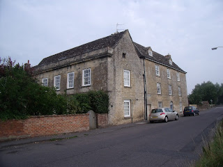
The priory dated before 1231 still survives today as a private dwelling.
This house has its own bridge across the Thames.
The farmer's bridge, which I had spent so long looking for, leading me back onto the path.
Once out of the town the river was disappearing fast.
It wouldn't be the Thames path without at least one herd of cows. These were in fact bullocks and I had to edge my way around the field to get past them.
The Cotswold Water Park is made up or 150 man made lakes and set in 40 square miles of countryside. The lakes were created to fill in disused quarry sites.
I had to climb over this gate to get close to the lake.
Ashton Keynes village
I followed the river through the village.
Fording the river.
Steve had left his car at the source and had come to walk the last few miles with me.
The sign on the lower step said ' No cyclists or horses'. I love to see someone try and get a horse over this narrow bridge.
There is still some water but it is very shallow.
The foliage seemed to be getting higher and higher.
Noticed this outside a house, a helpful sign for those walking in the opposite direction to myself - only 177 miles to the Barrier.
I would have loved more of these seats along the way. The seat was a gift from the Women's Insitute for the Thames Path walkers.
A dip in the riverbed and some water still remains but this is the last time we see any water covering the stones of the riverbed.
This two arched bridge is the first of the bridges over the Thames.
You can see the pebble route of the Thames which will lead us to the source.
This is Lyd Well, a stone enclosure surrounding an ancient spring, which is often thought to be the modern source of the Thames as there is usually water flowing from here, although not today.
The path of the Thames stretching into the distance.
Just across another field we come to the actual source of the Thames and the beginning of the Thames path but for me - the end of my walk along the path.
This marks the spot of the furthest place from the river where the water rises from the ground. For most of the year there is no water at all but there is water just below the surface and after heavy rain the whole field can be flooded.
For me this marks the end of the Thames path after 184 miles. It is an experience I will remember for many years to come and hopefully will return to visit many of the villages I passed enroute but didn't have time to explore.
Time to visit the nearest pub - The Thames Head to celebrate.
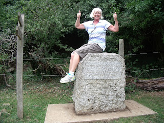
Just getting friendly with Old Father Thames for the last time.
Cricklade High street. Cricklade has saxon origins with its church, abbey and priory
This is what the river flowing through Cricklade looks like.
The priory dated before 1231 still survives today as a private dwelling.
This house has its own bridge across the Thames.
The farmer's bridge, which I had spent so long looking for, leading me back onto the path.
Once out of the town the river was disappearing fast.
It wouldn't be the Thames path without at least one herd of cows. These were in fact bullocks and I had to edge my way around the field to get past them.
The Cotswold Water Park is made up or 150 man made lakes and set in 40 square miles of countryside. The lakes were created to fill in disused quarry sites.
I had to climb over this gate to get close to the lake.
Ashton Keynes village
I followed the river through the village.
Fording the river.
Steve had left his car at the source and had come to walk the last few miles with me.
There is still some water but it is very shallow.
The foliage seemed to be getting higher and higher.
Noticed this outside a house, a helpful sign for those walking in the opposite direction to myself - only 177 miles to the Barrier.
The 16th cent Wild Duck Inn named because this is the first place on the river down from the source where you will see ducks.
I would have loved more of these seats along the way. The seat was a gift from the Women's Insitute for the Thames Path walkers.
A dip in the riverbed and some water still remains but this is the last time we see any water covering the stones of the riverbed.
This two arched bridge is the first of the bridges over the Thames.
You can see the pebble route of the Thames which will lead us to the source.
The path of the Thames stretching into the distance.
Just across another field we come to the actual source of the Thames and the beginning of the Thames path but for me - the end of my walk along the path.
The stone is inscribed with the words
The Conservators of the River Thames
1857-1974
This stone was placed here to mark
the source of the River Thames
This marks the spot of the furthest place from the river where the water rises from the ground. For most of the year there is no water at all but there is water just below the surface and after heavy rain the whole field can be flooded.
For me this marks the end of the Thames path after 184 miles. It is an experience I will remember for many years to come and hopefully will return to visit many of the villages I passed enroute but didn't have time to explore.
Time to visit the nearest pub - The Thames Head to celebrate.
Just getting friendly with Old Father Thames for the last time.


